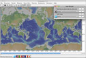
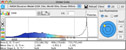
There are five new features in this release which include a new column labeled polyline for imported tables, a new NASA view icon, a new Slope Elevation (S/E) icon tool, a new warning icon, and a new About menu for Mac environment only. The new NASA icon is located on the main toolbar in GeoMapApp. It opens an Aster Elevation model in the Global Grids dialog box in a higher resolution than our existing GMRT Grid. The Node spacing is 10m US, 30m worldwide, 900m ocean. The Global Grids and Contributed Grids dialog boxes now include a toggle icon for elevation and slope distributions. Displayed in the lower area are the mean area, elevation, and slope. Imported tables may now contain a column labeled polyline, which consists of a sequence of comma separated longitudes and latitudes that define a line (i.e., ship tracks or seismic profiles). A polyline will now show on a map window. Selecting the line will bring you to the row in the table. If you are using GeoMapApp with Mac OS environment there is now a new About menu displayed in the Mac menus. The new release can be obtained three different ways: Visit http://www.geomapapp.org/
The GeoMapApp home page also features a new 'In The Classroom' section. A new version of Virtual Ocean 2.4.0 has also been released. It features Multi Channel Seismic (MCS) profiles and fence diagrams when a track is selected. Users can also import their own fence diagrams. Please email us with any problems, comments, and/or suggestions: info@geomapapp.org |
|
| Copyright © 2010 |